Snapshot
Union Environment Ministry’s Expert Appraisal Committee (EAC) for Infrastructure Projects raised concerns about Surat – Nashik – Ahmednagar stretch of Surat-Chennai Expressway which passes through the Western Ghats.
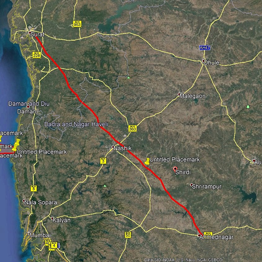
Months before the Gujarat assembly elections, the ambitious Surat – Chennai economic corridor project has encountered problems with its 290 km long greenfield Surat-Nashik-Ahmednagar stretch.
Surat – Nashik – Ahmednagar stretch passes through the Western Ghats, which are ecologically delicate.
The 1,271 km Surat-Chennai Expressway, which would cost Rs 14,000 crore, connects Gujarat, Maharashtra, Telangana, and Tamil Nadu. The expressway’s route passes via Nasik, Ahmednagar, Solapur, Kalburgi, Kurnool, Kadapa, and Tirupati.
The greenfield Surat – Ahmednagar economic corridor is a crucial component of the larger access-controlled connectivity plan between Delhi and Chennai.
During a meeting on 21–22 July, Union Environment Ministry’s Expert Appraisal Committee (EAC) for Infrastructure Projects recommended improving the National Highway alignment rather than cutting through “virgin, ecologically fragile new regions of Western Ghats lands.”
Also, in its 21 July meeting, the EAC noted that the existing road (NH-848) – Surat-Mumbai – is 136 kilometres long, while the proposed greenfield is 107 Km.
According to the EAC, after improving the existing road, the travel time would be three hours, but a greenfield corridor would reduce that time to one hour and ten minutes. This “marginal reduction” in travel time and distance in the new proposed alignment is anticipated to “over-weigh the cost of environmental impacts to the Western Ghat in the old path.”
It also noted that the benefits of developing new, ecologically sensitive sections of the Western Ghats near the planned route would outweigh the harms caused by the option of modifying, enhancing, or realigning the current road.
So, instead of pursuing the greenfield route across the Western Ghats, it has advised the NHAI to work on and complete the existing alignment in every respect.
According to The Economic Times report, the Ministry of Road Transport & Highways (MORTH) and the National Highways Authority of India (NHAI) are collaborating to ‘appeal’ to the Environment Ministry to reconsider its position and grant room for the national connectivity project.
Since November 2021, the EAC has been hearing on the matter.
The EAC then stated that the 70 metre Right of Way planned for the corridor would have a “significant effect” on the environment because it would pass through 428 hectares of forest land, directly affect 265 ha area, cross rivers like the Ambika, Kaveri, Kharera, Sasu, Man, Par, Godavari, Mula, and Dev Nandi, and affect 14,000 trees.
Any new alignment in the Western Ghats will have a “bad impact” on the ecology, and planned tunnels would affect the region’s water drainage systems.
It also formed a subcommittee for a site visit on April 20–21.
The NHAI then claimed that, compared to upgrading the current NH 848 in the Western Ghats region, the affected forest acreage, water bodies, and structures would be far less on the revised alignment.
However, the subcommittee agreed that the planned greenfield alignment had “few marginal advantages”.
NHAI stated that, even though the existing alignment has more of the endangered forest area, there has been continuous development there, and upgrading it will at least “save the pristine region of the proposed alignment.”
An official stated that they have always prioritised environmental concerns and are aware of them. The new alignment would lower the impacted area and use innovative technologies to minimise environmental harm. Although altering the current alignment would go against the corridor’s fundamental purpose, there are no other potential alternate alignments.
It is essential to ease the heavy traffic off the Surat-Maharashtra border on the existing highway, according to MORTH and NHAI officials. They argue that upgrading the existing NH 848 will defeat the very purpose.
They also stated that upgrading NH 848 in the western ghat topography will negatively impact the environment more than the tunnel and viaduct strategy intended for the new route.
Surat-Chennai Economic Corridor
The project is envisioned as a combination of 2 partially access-controlled economic corridors (Chennai-Solapur and Solapur-Surat). It will include the construction of greenfield stretches and upgrading of brownfield sections.
The expressway’s route passes via Nasik, Ahmednagar, Solapur, Kalburgi, Kurnool, Kadapa, and Tirupati.
The Surat–Solapur Economic Corridor (via Nashik–Ahmednagar) will be 564 km long, the Solapur Chennai Economic Corridor (via Kurnool) will be 707 km.
The stretches between Surat and Ahmednagar via Nasik and Akkalkot-Mahabubnagar section that links Maharashtra with Telangana will be developed as a greenfield alignment. The greenfield portion of the corridor will be close to 520 km. The rest of the corridor will upgrade existing two-lane roads.
The project will be developed on the Hybrid Annuity Model (HAM) that NHAI has preferred till recently.
Besides creating a third route by road between Chennai and Mumbai, the corridor seeks to reduce the distance roughly by 150 km between the two cities.
Currently, heavy vehicles from Chennai and other parts of the State take a detour via Karnataka to reach Mumbai, passing through a 1,604-km distance via Bengaluru, Tumukuru, Chitradurga, Davangere, Haveri, Belgaum, Kolhapur, Satara, and Pune. Alternatively, the second route via Nellore, Nalgonda, Hyderabad, Solapur, and Pune runs for 1,614 km.