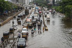
The project will aim to create a real-time flood monitoring and forecasting system that will provide citizens with a detailed, neighbourhood-specific image of waterlogging.
Nine reflection-based flood sensors will be set up at key locations such as Bandra-Kurla Complex (BKC) and Hiranandani Complex in Powai.
The Interdisciplinary Programme in Climate Studies (IDPCS) at IIT-Bombay will conduct a pilot of a flood monitoring and forecasting system for the city, during the upcoming monsoon season.
The project titled ‘Urban Flood Risk Map: Monitoring and Modelling’ will aim to create a real-time flood monitoring and forecasting system that will provide citizens with a detailed, neighbourhood-specific image of waterlogging, like checking the air quality index (AQI) with ease.
With this initiative, the team of researchers’ hope to help the city combat the effects of the monsoon season.
According to a Hindustan Times report, to gather data on waterlogging in the city, nine reflection-based flood sensors will be set up at key locations such as Bandra-Kurla Complex (BKC) and Hiranandani Complex in Powai.
The project’s success in its first year will determine the expansion of the sensor network, potentially spreading to dozens more in Mumbai.
Further to this, citizens will be encouraged to contribute anecdotal information via social media using #MUMBAIFLOODDATA along with geo-tagged images.
Subimal Ghosh, the institute chair professor at the Department of Civil Engineering at IIT-B, and convener of IDPCS, stated that FM radio seems to be the preferred source of information on waterlogged areas in the city.
To address this gap, the goal is to generate more reliable, real-time data on a dedicated web-portal to empower citizens.
The city of Mumbai has been hit by devastating floods twice, in 2005 and 2017, while most regions continue to be victims of waterlogging and flooding over the years.
While there have been ongoing efforts with infrastructure enhancements and planning initiatives to improve the improve the overall flood management, the citizens still lack crucial and actionable information to make important decisions in such situations.
As language is often ambiguous, numerical values can help in describing the level of potential risk.
Ghosh added, “For example, if someone says there is ‘waist-high’ or ‘ankle-deep’ water in a particular area, we can ascribe a numerical value to these general terms, and using rainfall information and a digital elevation map of the city, tell people with reasonable certainty how risky it will be to venture there. Using data on drainage and hydrological models, we can estimate how soon the waters will recede. There are many possibilities we are trying to explore”.
This project also aims to enhance the forecasting accuracy by utilising macro-level rainfall warnings issued by India Meteorological Department (IMD) for Mumbai.
Using AI and machine learning models, macro-level warnings will be transformed into specific alerts for each area to inform people about which regions to avoid during heavy rainfall.
The research team is currently identifying suitable locations to deploy flood sensors, including hospitals, schools, and traffic junctions.
Initially, the team will install the flood sensors in the Mithi River catchment area to collect data that can be generalised to other areas.
Raghu Murtugudde, a visiting professor at IIT-B and a professor of Earth System Science at the University of Maryland, states that floods can happen even during a dry monsoon season due to isolated extreme weather events that are becoming more common.
He emphasised that preparedness is crucial and through new methods it has become essential to provide more detailed and timely warnings to vulnerable communities.


