
The 22 km long Mumbai Trans-Harbour Link (MTHL), or Atal Setu, presents itself as a vital lifeline binding the island metropolis of Mumbai to its eastern expansion of Navi Mumbai.
This infrastructure marvel was inaugurated by Prime Minister Narendra Modi on 12 January, marking another milestone, while the city continues to witness advancements in enhancing connectivity.
In addition to inaugurating the Atal Setu, PM Modi also laid the foundation stone of the 9.2 km underground tunnel project between Orange Gate and Marine Drive.
This tunnel, linking the starting point of the MTHL to the coastal road, further contributes to the series of road projects underway in the form of sea links, coastal roads, tunnels and elevated roads.
But why is Mumbai investing and building this series of road infrastructure projects, which currently has made the city appear as a massive construction site, yet, holds global interests and anticipation of its millions of residents to achieve these advancements.
Despite being the country’s financial capital, the city has historically faced inadequacies in its infrastructure, relative to its economic growth and rapid expansion.
As Mumbai’s limits reached saturation, smaller cities and towns within the Mumbai Metropolitan Region (MMR) like Navi Mumbai, Panvel, Bhiwandi, Ulwe, Kalyan, Taloja, Vasai, Virar and Dahisar have witnessed substantial industrial and residential growth.
Furthermore, recognising the future potential beyond the growth of these regions, plans have also been proposed to develop a third Mumbai.
However, the growth has always been marred with insufficient transit connectivity between these regions.
The existing road capacities, struggle to cope with the growing travel volume and daily mobility needs for people, industrial and transshipment activities — leading to congestion and extended commuting hours in a city known for its fast-paced lifestyle.
Turning attention to the string of projects underway, each project holds its own significance in terms of improving connectivity. Given the scale, the projects are being launched in phases through different authorities.
However, beyond their individual significance, it is crucial to recognise that these projects are converging to redraw the overall transit network for MMR, which will go a long way towards addressing city’s key transit challenges.
Here’s the map to view the holistic imagination of the road network for city’s new transportation landscape. 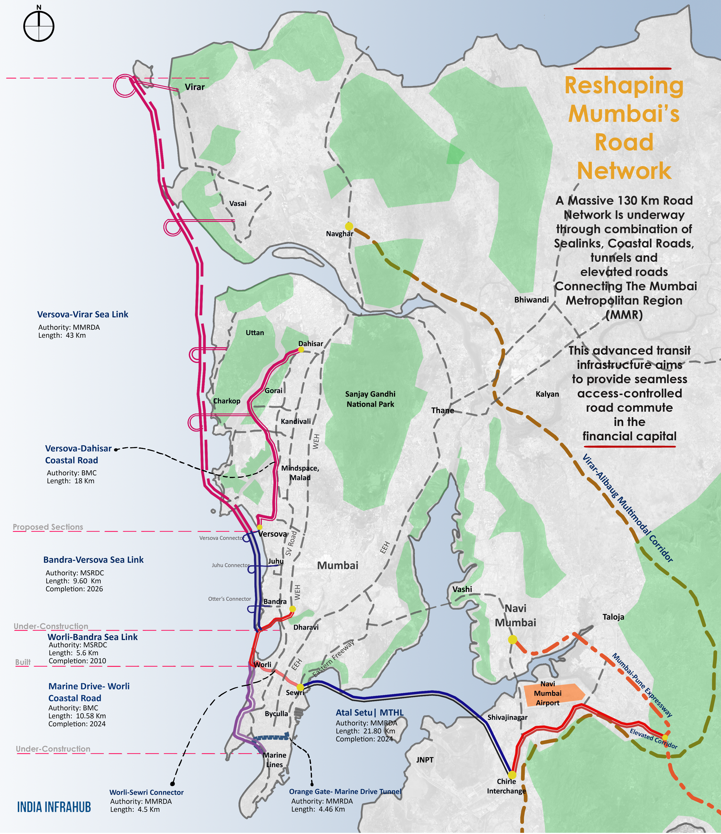
Infrastructure experts from the city believe that this network is shaping a ring road around MMR, with several interchanges giving access to maximum growing regions.
As the city’s urban footprint continues to grow, this will establish an integration with upcoming airports, metro corridors, and national highways across the MMR.
For instance, the opening of the Atal Setu not only enhances commute to Navi Mumbai but also lays the foundation for additional connectivity.
This sea link is set to be complemented by the proposed Ulwe coastal road, offering direct access to Mumbai’s second international airport in Navi Mumbai, and further with the Chirle-Palaspe elevated corridor linking to the Mumbai-Pune Expressway.
Similarly, the north-south network comprising coastal roads and sea links, stretching from the south Mumbai to Virar, aims to integrate various northern regions with the mainland. Given Mumbai’s linear layout, travel in north-south direction remains key.
Planned to cut travel time by 60 per cent and reduce fuel consumption by 35-40 per cent, this network will ease congestion on the Western Express Highway (WEH), as well as the internal S V Road and Link Road.
Residents in the northern areas, such as Vasai, Virar and Palghar, currently face a two-hour commute to Mumbai, presenting challenges for daily travel, commerce, and even medical emergencies due to limited options.
To further facilitate north-south-east integration, two connectors are proposed running across the mainland. In addition to the previously mentioned tunnel between Orange Gate and Marine Lines, the 4.5 km Sewri-Worli elevated connector is underway, linking the Bandra-Worli Sea Link (BWSL) and the MTHL.
Sagar, a Mumbai resident and infrastructure enthusiast, says, “this evolving network will streamline the city’s traffic, a longstanding challenge due to Mumbai’s fast-paced and bustling systems. The Maharashtra Government understands the urgency of this transformation, and is actively expediting all projects through its war rooms.”
He adds, “the overall integration will enable vehicles to bypass the main city, which has been adding to the traffic presently. Whether heading to the upcoming airport or exiting the city, one can use any interchange to access this network, reaching their destination or leaving Mumbai in less than half the current time.”
On completion of this network of nearly 200 km, including the 130 km of sea links, coastal roads, tunnels and elevated roads, added with the Virar-Alibaug corridor, Delhi-Mumbai Expressway’s JNPT spur, there will be a monumental shift in the road transit landscape of the region.
With investments exceeding Rs 1 lakh crore through international fundings, majorly supported by Japanese International Cooperation Agency and Asian Development Bank, who are mindful of future perspectives, Mumbai, as the economic capital of India, deserve such an advanced transport infrastructure.
The network, added with the metro network currently under development, will open up the emerging areas to further economic opportunities, also for locals and professionals looking for quality and well-connected residential options in the region.