
Beyond providing commuters with a world-class travel experience, the coastal road will also be reshaping Mumbai’s shoreline, with new green spaces, promenades and recreational areas.
As Mumbai’s urban footprint continues to grow, an extensive strategy aimed at overhauling the city’s transportation landscape is presently in progress.
This initiative involves the development of advanced road networks, metro corridors and other mass transit systems, all of which will go a long way towards addressing one of the city’s key challenges: reducing congestion and providing enhanced commute with top-tier facilities.
According to a study, Mumbai is projected to reach a population of 34 million by 2031. UN Habitat data further highlights Mumbai as the world’s second most densely populated city, accommodating approximately 31,700 individuals per square kilometre.
For decades, Mumbai has functioned as a pivotal growth engine for both the state and the nation, attracting substantial resources and populations.
However, this expansion has taken a toll on the city’s transportation system. Both public transportation and road networks are grappling with overwhelming strain as the city can be seen facing persistent traffic and long commute hours.
Evidently, the juxtaposition of cars, populace, and land is exerting significant burden on Mumbai’s 603-square-kilometre area.
Anticipating the city’s expansion and the economic upsurge it aims to achieve, the vitality of commute in this thriving metropolis becomes paramount.
This calls for the setting up sophisticated transportation networks that accommodates the burgeoning demands of the city — with a holistic approach towards vehicular transit, mass rapid transit systems, and infrastructure advancements aimed to transform the transit pattern of the city, while being mindful of future perspectives.
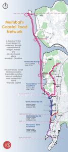
Mumbai’s Network Of Coastal Roads And Sea Links
From the current string of projects conceived, Mumbai is developing a high-speed road corridor to enhance movement between north and south Mumbai — through a network of coastal roads and sea links.
Mumbai is surrounded by the sea on three sides, and is linear in shape for which travelling is mostly in north-south direction.
This seamless road network has been proposed under different phases to run along the city’s coastline and
The network includes the coastal road project connecting Marine Lines to Worli and linking to the already built Worli-Bandra sea link.
Further, it includes the under-construction Bandra-Versova sea link, and the Versova-Dahisar coastal road.
Additionally, the longest sea link connecting Versova to Virar is also under the proposal stages.
In 2009, the 5.6 km Bandra-Worli Sea Link (BWSL) marked Mumbai’s first sea-link project in the attempt to offer uninterrupted north-south connectivity. As a source of pride for the city, it stands as India’s inaugural eight-lane freeway over the open sea, linking Bandra to Worli in South Mumbai.
Looking ahead, after 14 years, the first phase of the coastal road is set to open, transforming Mumbai’s shoreline once more while facilitating faster travel.
Mapping Mumbai’s Coastal Road Network (Source: Swarajya)
Marine Lines To Worli Coastal Road
The 10.5-km-long, first phase of the Mumbai Coastal Road Project (MCRP) is expected to open for public use by the end of this year. The stretch will connect Nariman Point in the southernmost tip of Mumbai to the Bandra-Worli Sea Link.
The sprawling corridor is being constructed by the Brihanmumbai Municipal Corporation (BMC). It is the first to be completed in this series of ambitious road projects to transform the north-south travel in the city.
The road will decrease the commute time from Girgaon to Worli from 45 minutes to 10 minutes during peak hours providing relief to lakhs of commuters. It will have three interchanges — Haji Ali, Worli, and Amarson’s junction.
Additionally, the coastal road also seeks to create large patches of open green space, along the city’s coastline.
As per reports, the stretch is also set to reduce fuel consumption by 35 per cent, besides bringing down noise and air pollution reducing carbon footprint by 1,826 ton annually.
Versova-Bandra Sea Link
Extending the connectivity from the Bandra-end of the BWSL, the Versova-Bandra Sea Link (VBSL) is presently in the construction phase.
This project aims to link Bandra with Nana Nani Park in Versova and is being managed by the Maharashtra State Road Development Corporation (MSRDC).
The sea link spans 17.17 km — making it three times longer than the 5.6 km BWSL. The main sea link bridge will be 9.60-km with four lanes in each direction.
It also provides interchanges at Bandra Connector, Carter Road Connector, Juhu Koliwada Connector and Nana Nani Park Connector.
Initiated in 2019, the sea link project was originally scheduled to finish within 60 months from the contract start. However, the revised completion deadline for the project is now set for December 2026.
The VBSL has two further extensions in the pipeline— the Versova to Dahisar coastal road and Versova-Virar sea link, to connect further regions in the north.
Versova-Dahisar Coastal Road
The 18 km link road will be the second phase of the MCRP — which will connect Versova in the western suburbs with Dahisar in the northernmost part of the city.
According to recent reports, the BMC has opened bidding for all packages of the Rs 16,621 crore Versova-Dahisar phase on 5 August.
Upon completion, this extension to the coastal road is projected to reduce travel time by 70 per cent, offering relief to congestion on SV Road, Link Road, and Western Express Highway (WEH) — which are currently the primary routes between north and south Mumbai.
The Versova-Dahisar extension will comprise of six packages (read more on this here) and the sections will be a combination of elevated bridges and underground tunnels providing seamless connectivity.
Versova-Virar Sea Link
The second proposed extension is the 43-km elevated road, which will connect Versova to the fast-growing residential hub of Virar, with multiple connectors through its long span.
In addition to the elevated road over the sea, the project also includes the construction of approximately 60 km of suburban roads, including connector roads towards Charkop, Uttan, and Vasai.
The Versova-Virar sea link was initially to be built by the MSRDC. The authority had planned to extend the upcoming Bandra-Versova sea link until Virar, in line to possibilities presented by Tata Consulting Engineers in its pre-feasibility assessment sought in 2019.
However, the project was transferred to Mumbai Metropolitan Region Development Authority in October last year.
This longest sea link of the network, will further support in relieving congestion on WEH, as well as, internal S V Road and Link Road.
It has an estimated budget of Rs 63,426 crore and would be the city’s costliest sea link.
A Monumental Shift In Road Transit
On completion of this extensive network comprising approximately 90 km of sea links and coastal roads, Mumbai’s transportation paradigm is set for a significant transformation.
As the economic capital of India, the progress of Mumbai and its population well deserve such advanced transport infrastructure.
Beyond providing commuters with a world-class travel experience, the coastal road will also be reshaping Mumbai’s shoreline, with new green spaces, promenades and recreational areas in a in a city challenged by space constraints.
While the executing nodes for the all sections stand different, the collective efforts for the overall network will ensure access-controlled signal-free connectivity between the south and north of the financial capital.
Furthermore, the advent of these developments has also opened up entry points for innovations, modern design and engineering approaches, which can propel Mumbai into global ranks of such advanced infrastructure.
Highlighting this is the first phase of the coastal road, which has created its own unique set of records.
The 2.07-km-long twin tunnels that will connect Marine Drive with Priyadarshini Park, is the country’s first undersea tunnel — with a 1-km stretch in Girgaon passing 17 to 20 metre below the Arabian Sea.